#kenringwatch results for November, December and 2014!

Happy New Year!  With the old year now over, we can look back at Ken Ring’s final predictions for the winter, his “overall” predictions for the year, and how he did in total.

So the last few predictions – sorry, he’s calling them “suggestions of potential” now – for #kenringwatch 2014, were as follows:

Nov
25. Mild temperatures up to November (1)
26. 19th November, subzeros back (1)

Dec
27. 4th to 9th, first snow of winter (1)
28. No white Christmas, but subzero on the 24th, 25th (1)

How did Mr Ring do?

25. Yes, absolutely, this autumn and winter have been mild.  In fact, Met Éireann tells us “Many stations recorded their highest maximum temperatures for winter in 6 to 15 years. Lowest minimum temperatures were the highest for winter on record at many
stations, Shannon Airport reported its highest minimum for winter in 68 years” (2) 
I might put that down to climate change – Ken would disagree, as would, according to him, most Irish farmers, who are immortal, or something, and know all of this is just cycles

Regardless of the reasoning, though, that’s definitely a point for Ken.

26. Ah, I love these black or white predictions. The Met Éireann report for November tells us that November was “Typical for the time of year, milder at the start of the month.”  That report tells us that the 19th was a perfectly average day for the month – minimum temperatures between 5 and 10 degrees Centigrade, max between 10 and 15.  Certainly not subzero.

November: One for two.

27. The monthly report for December hasn’t been published yet on Met Éireann, which means checking various weather stations for particular dates.  Let’s pick Cork, Dublin, and Shannon Airports, and Malin Head. Checking them each day from the 4th to the 9th, we find:

Cork: Too warm for snow and/or little to no precipitation;
Dublin: Same;
Shannon: Same;
Malin Head: Yes, same.

No snow. No points.

We then got a cold snap and severe winter storm, which Ken didn’t mention. That brought snow – but it didn’t arrive until the 11th, didn’t last long, and only hit a few counties.

28. Ken was correct about no white Christmas, but the lowest temperature recorded over both days at the aforementioned weather stations was 0.8 degrees Centigrade.  Predicting no white Christmas is a banker (it very rarely is), but them’s the breaks.  Half a point.

December: 0.5 for two.

Ken also made two “general” predictions that we couldn’t measure until the year was over:

1. The coming winter (2013/14) won’t be severe (3)
2. No hotter than 25 or 26 degrees at any point in the year (1)

1. Looking back to the Winter 2013/2014 report for this one. The report headline tells us: “Stormy at times; wettest winter on record”.  Under the various headings, it goes into more detail: “Over 50% of stations across the country reported it was the wettest winter on record. Valentia Observatory reported its wettest winter since records began in 1866 (148 years) with 848.0mm and 183% of LTA, while Malin Head reported 530.7mm, 164% of LTA its wettest winter since records began in 1885 (129 years). Shannon Airport had its wettest winter on record (68 years) while Mullingar reported its wettest winter on record (63 years).”  Similarly, for wind speed, we’re told: “Winds were above average for winter with storm force winds on occasions. Dublin Airport’s winter mean windspeed value of 14.4 knots (26 km/h) was its highest since 1943 (71 years), Shannon Airport reported its highest winter mean windspeed in 31 years” and “The highest gust of the season was 86 knots (159 km/h) at Shannon Airport on the 12th February, its highest for winter on record (68 years).” , and “A new record maximum wave of 25 metres was reported at the Kinsale Energy Gas Platform on February 12th.” 

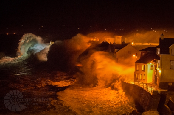
These records were due to the series of severe storms that arrived in January and February, and about which Ken said nothing.  But a picture paints a thousand words:
Lahinch Promenade during January storm

Lahinch promenade during one of January’s storms. Photo by George Karbus, http://www.emerald-vision.com/

Zero points.

2. Most annual highest maxima were recorded during July. The year’s highest temperature
was 31.0°C recorded at Dooks, Co Kerry on Saturday, July 19th, the stations second
highest maximum since it opened in 1997.  Five degrees higher than predicted – so, zero points.

“Overall” category: Zero for two.

Total for the year: Seven for twenty-eight. 25% accuracy, exactly.

Ken Ring claims 80% to 85% accuracy, but it turns out that when you record his predictions, and check back, then being generous, he’s right one time in four, on average.  Half as accurate as a coin-toss.

Conclusions:

1) Moon and tides are of no use whatsoever in predicting the weather.

2) Spending €50 plus postage and packing for an almanac that’s right (presumably) one time in four would not appear to be a good investment.

“It’s just a bit of harmless fun” is sometimes repeated by reputable journalists as a reason for allowing Ken Ring to use their publication or programme to publicise his almanac.  Well, he can’t be done under the Trade Descriptions Act (or else Old Moore’s Almanac would be out of business) – but he is selling his pseudoscience “predictions” at €50 a shot and claims to be selling 1,000 a year.  Which would be great if it was accurate, but not when the accuracy is only half as good as a coin-toss.  In my opinion, file under crank, snake-oil, or charlatan.  If you must invite him on to your show to fill a slow news day, then also invite on a pseudoscience skeptic, or a spokesman from Met Éireann. I suggest Evelyn Cusack.

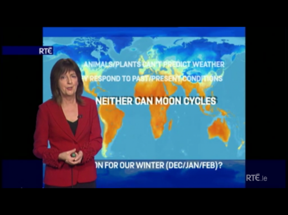
Source: RTE Player screengrab via thejournal.ie

Source: RTE Player screengrab via thejournal.ie

Sources:

(1) http://www.todayfm.com/player/podcasts/The_Last_Word_with_Matt_Cooper/The_Last_Word_with_Matt_Cooper/8455/0/ken_rings_2014_weather_predictions

(2) http://www.met.ie/climate/MonthlyWeather/clim-2014-win.pdf 

(3) http://www.radiokerry.ie/news/new-zealand-weather-forecaster-predicts-a-typical-irish-winter/
#kenringwatch results for September

The number of views on here has shot up recently. Wondering why, I googled, and yep, Ken Ring has released his “almanac” for next year (at a mere €51 incl. P&P) and the usual suspects published his press releases, with few (or no) questions asked. Which led to more people googling for him, and the happy side effect that many people are finding out the truth about his accuracy, by landing here. Which is good.

Interesting question, though – if the moon is the be all and end all when it comes to weather prediction (as claimed by Ring), then why not just release your prediction algorithm into the public domain? After all – we know exactly where the moon is going to be, pretty much forever. So, in the 21st century, why release a paper almanac, once a year, when you could just release an app?

Wait… it wouldn’t be all about parting credulous people from their money, would it…?

Anyway – #kenringwatch results for September! Ken’s predictions were:

Sep
22. 8th to 30th, no rain anywhere
23. 22 to 23 degrees, more in the 3rd week
24. Not much sunshine except last week

How did he do? Well, using Met Éireann’s report for the month, we find:

22. “Monthly rainfall totals were below average everywhere… Low rainfall totals in parts of the South, Southwest and West were due to a period of absolute drought (a period of 15 or more consecutive days with less than 0.2 mm) between the 1st and 21st, with most of these stations reporting their driest September at least 28 years.”  So, although it did indeed rain between the 8th and 20th, I think it’d be churlish to not give Ken a mark for this one.

23. A very specific prediction here – a rarity for Ken.  Met Éireann: “The month’s highest temperature was 23.9°C at Shannon Airport (on the 4th), its highest since 2004 (10 years)… Highest mean monthly temperature: 15.7°C at Valentia Observatory (its warmest September since 1991).”  The handy chart on their monthly report shows that although September was bright and dry, unfortunately, it wasn’t very warm. And it got distinctly cooler in the third week, when Ken thought it’d be getting even warmer. Zero marks.

24. “Sunshine totals were all near or above average with the percentage of average values ranging from 95% at Casement Aerodrome to 144% at Valentia Observatory. Valentia Observatory was the sunniest place, recording over 166 hours of sunshine and its sunniest September since 1972 (42 years). The month’s sunniest day was the 10th at Belmullet with 12.3 hours, it sunniest September day since 1969 (45 years). Number of dull days (days with a high amount of cloud cover recording less than 0.5 hours of sunshine) was up to eight at Casement Aerodrome and Knock Airport.”  So, yeah, bright and sunny.  Zero marks.

September: One for three.

Total: 5.5 out of 21.  26% accuracy – the average continues to rise!

#kenringwatch results for June, July and August!

#kenringwatch is like waiting on a bus – nothing for ages, then three come along at once. Results for June, July and August are finally here – apologies for the delay.

In related news, Jamie points out in the comments on the May results post that Ken Ring is actually less accurate than a coin toss.  His work is available on the Silly Beliefs website – where an article on Ring’s pseudoscience has resulted in over 550 comments being posted!

Those comments are an interesting read… disappearing posts after the fact, other major misses, and failures to predict major events.  But then that’s only to be expected.

Ring has also popped up again recently in the comments to my original 2014 #kenringwatch post, where he says:

“I have also had a fair degree of success for this year with my Ireland almanac. I said no records would be broken this year and no extreme events would be likely.”


He forgot Christine and her sisters… the most severe storms to hit Ireland in years. Or that his accuracy for 2014’s Irish weather predictions is currently languishing at 20%.

Anyway – June, July, August. The predictions were:

Jun
19. Last week of June the hottest.

Jul
20. Last week of July the hottest.

Aug
22. Lot of wet days interspersed with dry days.

So, two easily testable predictions, and one completely vague one.

June: “The majority of highest maxima were recorded between the 16th and 18th during the mid-month period of high pressure, with the highest maximum of 27.1°C recorded at Newport, Co. Mayo on the 17th.” Zero marks.

July: “Nearly all highest maxima were recorded between the 23rd and 25th, with the month’s highest temperature recorded at Carlow (Oak Park) on the 25th with 27.6°C.” Ooh, close – the 25th is seven days from the end of the month, so one of the hottest days was technically within the last week. Let’s be generous and give half a mark.

August: How do you interpret “Lots of wet days interspersed with dry days”? The Met Éireann monthly report has a one-line summary: “Dry in parts but extremely wet in the East; cool everywhere ”  Other stations in the Dublin area and at Mullingar reported their wettest August days in 28 to 64 years, with rainfall analysis of their 24-hour totals reporting the events to have rainfall return periods of between five and 20 years. Dublin Airport, in the east had 20 rain days, 11 with no rain. Claremorris, in the west, had 26 rain days, only 5 with no rain.  So, certainly, “lots of wet days” is correct. I think Ken gets this one.  But it would have been nice if he’d said “Wettest August in years!”

June, July, August: One and a half for three.

Total: Four and a half out of eighteen.

We’re up to 25% accuracy!

#kenringwatch results for January. No earthquakes!

In prediction version 1 (on air, Today FM and Radio Kerry), Ken Ring said:

3. “Mr. Ring says that 2014 will bring in bitter cold temperatures of -10ºC as the new year is rung in.”
4. Snow Jan 9th & 10th snow in midlands

In version 2 (in the comments on that linked post), Ken Ring widened his prediction:

3. 2014 could bring in cold temperatures of perhaps up to -10ºC in the north in the first 10 days of January.
4. Moderate snowfall possible (nothing is ever definite in weather forecasting) within a day or so of Jan 9th & 10th in midlands

Well, our most northerly weather station is Malin Head.  You’ve to play around on this Met Éireann page, but you can select weather stations and dates.  Malin Head, 1st Jan: a cool 3.2C, up to 7.2C.  On the 2nd and 3rd – roughly the same.  The 4th is a little cooler – it drops to nearly zero.  But nowhere near -10 degrees centigrade.  Zero for one.

So, snowfall.  On the 9th or 10th.   Or 7th, 8th, 9th, 10th, 11th or 12th, in the second “Whoops, someone took note!” predictions.  But – we had no snowfall at all in the midlands.  Or anywhere else. Zero for two.  Under both sets of predictions.

I’ll also refer you again to this post, where the Auditor General states:

“For ice warnings and severe weather alerts, there are three possible outcomes which can be monitored

  • hit: where the forecasted weather actually occurs
  • miss: where the forecaster fails to predict an exceptional weather event
  • false alarm: where adverse weather is forecast but fails to materialise.”

This seems a fair way to measure predictions.  You’d imagine that the most severe storms to hit Ireland in years might have merited a mention from Mr Ring when he was talking to Matt Cooper, but nope – not a dickie bird about storms.

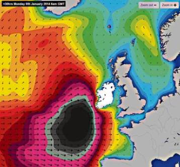
Storm Christine inbound

Storm Christine inbound

January’s Storm Christine, by the way, is estimated to have cost in the region of €300 million in damages.   I’d call that a miss.

But, in fairness, we never said we’d measure misses, so we won’t count those.  (Although, despite claiming to have predicted the Christchurch earthquake, there’s nothing on Mr Ring’s site at all about today’s 6.2 magnitude earthquake on New Zealand’s North Island, either.  There’s a lot about climate change denial, though.)

An interesting couple of days ahead for #kenringwatch

Today and tomorrow are the next days of interest for #kenringwatch.  “Snow Jan 9th & 10th, snow in midlands” was the prediction.  Notably, Mr Ring modified that to “Moderate snowfall possible (nothing is ever definite in weather forecasting) within a day or so of Jan 9th & 10th in midlands” in the comments on my last post.

Of course nothing is definite in weather forecasting.  Nobody said otherwise.  Ken Ring claims an accuracy rate of 80% to 85%, though. Which would be impressive if it’s borne out.  That’s up there with the last accuracy reports relating to Met Éireann.  Mr Ring asks why I’m not tracking their progress, in comparison to his.  Well, the main reason is that to compare like with like, Met Éireann would need to make long range weather forecasts for the whole year ahead, specifying events such as snow or rain on specific days (or, perhaps, “within a day or so” of specific days).  And as that’s scientifically impossible, they simply don’t.

Mr Ring also questions why I’m not checking Met Éireann’s past accuracy, given that I pay for their services.  Well, not my job.  But somebody does – they’ve been audited in the past by the state’s Auditor General.  They say in part:

“For ice warnings and severe weather alerts, there are three possible outcomes which can be monitored

  • hit: where the forecasted weather actually occurs
  • miss: where the forecaster fails to predict an exceptional weather event
  • false alarm: where adverse weather is forecast but fails to materialise.”

and

“A special exercise to consider the accuracy of severe weather alerts (fog, wind, snow and rain) in the period November 1998 to January 1999 indicated a hit rate of 92%.”

Not bad.  Admittedly, those figures are for 15 years ago.  But with improvements in instruments and software, I can’t imagine that Met Éireann has become less accurate over time.  It is an issue that Met Éireann’s last issued annual report (which also contains accuracy figures) was for 2007, and that they’re no longer reporting on their accuracy due to staff and budget cuts.  I don’t think that’s useful at all – how can you improve if you don’t know where you’re starting from?

But they are still providing short term forecasts that, on the face of it, seem reasonably accurate to me, rather than being jarringly inaccurate.  They’re also providing and contributing to scientific studies such as this one, on global climate change (pdf).

Oh – Mr Ring doesn’t believe in climate change, either…

But speaking of 2007, it turns out that someone else was checking Ken Ring’s accuracy back then.  Oh dear…

Announcing Ken Ring Watch 2014 – #kenringwatch

So true to form, my prediction from early last year came to pass – Ken bloody Ring reappeared on our airwaves, peddling his “weather almanacs”, that he claims are based on tides, the moon, and past events.  Unfortunately, unlike 2013, I didn’t have time to go back and check his predictions for the year just over. But why don’t we try a little experiment for 2014?  Let’s call it #kenringwatch.

On The Last Word, Ken Ring claims an accuracy of 80% to 85%.  Which would be impressive if it were true.  I don’t believe his claim, because, a) if he could get anything wrong in 2012, he did, and b) his “science” is, frankly, bullshit.

All he’s doing is drumming up traffic for his website and his real business of selling “almanacs”.  But as Today FM and our other media outlets never seem to challenge him on his claims or past predictions, he gets away with it.

But we have his predictions for 2014 – reproduced below, and with links to the broadcasts and news stories (thanks to Joe Whyte for the links to Radio Kerry, which Joe posted  in the comments on this Greenside Up post).  So – let’s measure Ring’s predictions, month by month.

He makes 28 predictions, reproduced below.  Ring claims 80% to 85% accuracy. (1)  That means Ring needs to get between 22.4 to 23.8 of his predictions correct.  Rounding, that’s 22 to 24 out of 28 predictions.  Admittedly, some are vague.  “The coming winter won’t be severe”, he said back in September – but what defines severe?

Lahinch Promenade during January storm

Lahinch promenade during one of January’s storms. Photo by George Karbus, http://www.emerald-vision.com/  (Not severe, per Ken Ring).

And some predictions are contradictory.  He says on The Last Word that February’s snow won’t be heavy, but on Radio Kerry, he says it’ll be “intense.”  Maybe that’s just in Kerry?

Anyway – we’ll measure his predictions here, month by month, and see how he fares.  And maybe, just maybe, if he scores less than 50%, Matt Cooper will forego the “slow news day, what can we use as a filler, oh, let’s get Ken Ring on!” temptation in 2015?

Check back in early February, where we’ll see how he fared for January, and then month by month…

The predictions: 

Overall:

1. The coming winter (2013/14) won’t be severe (2)
2. No hotter than 25 or 26 degrees at any point in the year (1)

Jan
3. “Mr. Ring says that 2014 will bring in bitter cold temperatures of -10ºC as the new year is rung in.” (3)
4. Snow Jan 9th & 10th snow in midlands (1)

Feb
5. Heavy month for snow in terms of number of days of snow, but it won’t be heavy (1)
6. Snow on 5th and 6th (1)
7. Snow on 14th to 19th (1)
8. Most concentrated snow time of the winter (1)
9. Snow “Intense” from mid-February onwards (2) (how this squares with The Last Word, where he says it won’t be heavy, I’m not sure)
10. February expected to be bitterly cold and snowfalls expected around Valentine’s Day. (3)
11. Kerry, he says, may get the heaviest falls around Feb 17 to 19. (3)

Mar
12. March 3rd to 7th, light snow flurries (1)
13. Snow 19th and 20th (1)

Apr
14. Subzero(!) temperatures finish around April 19th (1)
15. Snow 22nd April (1)

May
16. Lots of sun, 14th to 20th/21st (1)
17. Snow 30th May (1)
18. 3rd week of may, very cold (subzero?) temperatures (1)

Jun
19. Last week of June the hottest (1)

Jul
20. Last week of July the hottest (1)

Aug
22. Lot of wet days interspersed with dry days. (1)

Sep
22. 8th to 30th, no rain anywhere (1)
23. 22 to 23 degrees, more in the 3rd week (1)
24. Not much sunshine except last week (1)

Oct
(Nothing said at all about October)

Nov
25. Mild temperatures up to November (1)
26. 19th November, subzeros back (1)

Dec
27. 4th to 9th, first snow of winter (1)
28. No white Christmas, but subzero on the 24th, 25th (1)

Sources:

(1) http://www.todayfm.com/player/podcasts/The_Last_Word_with_Matt_Cooper/The_Last_Word_with_Matt_Cooper/8455/0/ken_rings_2014_weather_predictions

(2) http://www.radiokerry.ie/news/new-zealand-weather-forecaster-predicts-a-typical-irish-winter/
(3) http://www.radiokerry.ie/news/forecaster-predicts-heavy-snowfall-in-kerry-in-february/